

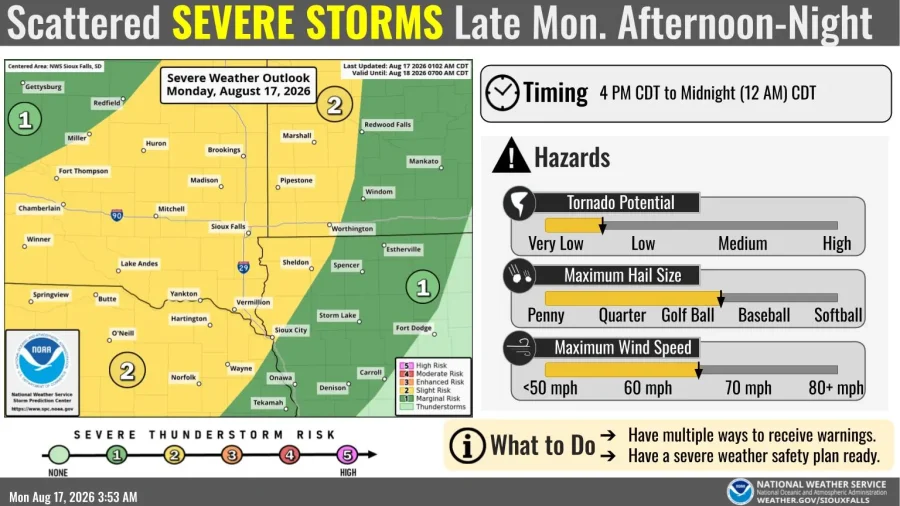



Thunderstorms may develop after 4 p.m. Aug. 17, with the greatest risk after 7 p.m. Storm chances spread into central Iowa overnight and eastern Iowa Tuesday.
Last verified: Monday, Aug. 17, 2026, at 10:45 a.m. CDT.
Strong to severe thunderstorms could develop across northwest Iowa after 4 p.m. Monday. The greatest risk is expected after 7 p.m., according to the National Weather Service in Sioux Falls.

The strongest storms could produce hail up to 2 inches in diameter and wind gusts up to 65 mph. In addition, the tornado risk remains low but is not zero.
The outlook covers Lyon, Osceola, Dickinson, Sioux, O’Brien, Clay, Plymouth, Cherokee, Buena Vista, Woodbury and Ida counties. It includes communities such as Sioux City, Storm Lake, Spencer, Le Mars, Cherokee and Orange City.
No severe thunderstorm watch or warning was in effect for Iowa at the time of the latest verification. Therefore, the forecast describes a developing risk rather than an active severe weather alert.

The greatest storm risk begins after 7 p.m.
Isolated or scattered storms may begin after 4 p.m. However, the chance for severe weather increases during the evening. The strongest period is expected after 7 p.m.

The severe threat should begin to decrease after 10 p.m. Then, it is expected to become low after midnight or 1 a.m. Tuesday. Still, gusty thunderstorms could continue into the Tuesday morning commute.
The exact number and location of the storms remain uncertain. Some areas may receive multiple storms, while nearby communities may see little activity.

Central Iowa could receive storms after midnight
Storms moving out of South Dakota, Minnesota and Nebraska could reach northern and central Iowa late Monday night. A damaging wind gust will be possible in northwest Iowa, although the severe threat may weaken farther into the state.
Another group of storms could move from Nebraska into Iowa late Monday night or Tuesday morning. That activity may maintain a damaging wind threat longer, especially west of Interstate 35.

Additional storms are possible Tuesday afternoon. Large hail and damaging winds cannot be ruled out. Meanwhile, repeated storms could produce locally heavy rain across the southern half of Iowa.
Related: A previous flood watch covered Des Moines and the Quad Cities through Aug. 15.
Quad Cities storm risk shifts to Tuesday afternoon and evening
Davenport, Bettendorf, Moline and Rock Island are expected to remain dry through most or all of Monday night. A weakening area of showers could reach northern sections of eastern Iowa before Tuesday morning.
Storms
Storms may develop in the Quad Cities region as early as late Tuesday morning. However, more organized activity is possible during the afternoon and evening. Damaging wind would be the primary severe weather concern.
The severe threat for the Quad Cities has decreased compared with earlier forecasts. Still, a few strong or severe storms remain possible if the atmosphere recovers after morning rain.
Current forecasts vary across Iowa
- Northwest Iowa: Storms possible after 4 p.m. Monday, with the greatest severe risk after 7 p.m.
- Central Iowa: Storms could arrive after midnight and continue Tuesday.
- Southern Iowa: Locally heavy rain is possible Tuesday where storms repeatedly cross the same areas.
- Quad Cities: Storm chances increase Tuesday, especially during the afternoon and evening.
Forecast changes and active warnings for northwest Iowa are available through the National Weather Service in Sioux Falls. Central Iowa conditions are available from NWS Des Moines, while eastern Iowa and western Illinois updates appear through NWS Quad Cities.
As of 10:45 a.m. Monday, no severe thunderstorm watch was active for Iowa. The first storms could develop after 4 p.m. in the northwest, with the greatest risk after 7 p.m.
Stay in the know with stories that matter — visit HolaAmericaNews.com for the latest news, culture, and community updates!
Facebook Comments