
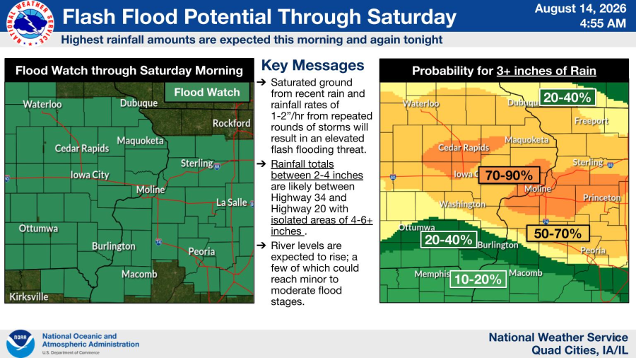



The National Weather Service ended the watch at 10 a.m. after the immediate flash-flooding threat decreased. Later reports documented heavy rain and flooded roads in eastern Iowa and western Illinois.
Updated Aug. 26, 2026.
By Hola America News

Status update: This flood watch expired at 10 a.m. Saturday, Aug. 15. This article has been updated as a record of the weather event and does not describe an active alert.
IOWA AND ILLINOIS — The flood watches that covered Des Moines, Davenport, Bettendorf, Moline, Rock Island and surrounding communities expired at 10 a.m. Saturday, Aug. 15.
The National Weather Service offices in Des Moines and the Quad Cities said the immediate flash-flooding threat had ended. Therefore, the watches were allowed to expire at their scheduled time.
The expired alerts covered much of central and eastern Iowa, along with several counties in western Illinois. However, inclusion in a flood watch did not mean flooding occurred in every city or county.
Later storm reports documented flooded roads and high rainfall totals in parts of eastern Iowa and western Illinois. Those reports describe the outcome of the Aug. 13–15 weather event, not a continuing alert.


The flood watches expired at 10 a.m. Aug. 15
The Des Moines watch included Polk, Dallas, Jasper, Warren, Marion and other central and southern Iowa counties. The Quad Cities watch covered Scott, Muscatine, Clinton, Johnson, Linn and other eastern Iowa counties.
In Illinois, the Quad Cities watch included Rock Island, Henry, Whiteside, Carroll, Bureau, Putnam, Mercer and several nearby counties.

Shortly before the watches expired, both National Weather Service offices reported that the immediate flash-flooding threat had decreased. Still, the Quad Cities office advised people to avoid locations where water remained over roads or other surfaces.
A future flood threat would require a new, dated National Weather Service alert Service alert. Current conditions for central Iowa are available from the National Weather Service office in Des Moines. Residents of eastern Iowa and western Illinois can use the National Weather Service Quad Cities forecast.
Parts of eastern Iowa and western Illinois received heavy rain
The National Weather Service Quad Cities later compiled rainfall observations for the 72 hours ending Aug. 16. The list included 8.75 inches near Wapello, Iowa, and 7.09 inches in Aledo, Illinois.
Other listed totals included 2.66 inches at Quad City International Airport and 2.34 inches at an observation site near Davenport. Totals varied widely because the strongest storms repeatedly crossed some locations while producing less rain elsewhere.
The agency noted that the observations came from several reporting networks with different equipment and exposures. Therefore, not every listed measurement carries the same official status.
Flooding affected roads from Fort Madison to New Boston
Local storm reports documented more than one foot of water on some streets in Macomb, Illinois. A gravel road also washed out near Colchester.
In Iowa, roads north of Fort Madison closed after nearby creeks sent water over the pavement. Street flooding was also reported in Grandview, where water covered parts of the road.
Later on Aug. 15, law enforcement reported water over Highway 17 near New Boston, Illinois. The reports occurred during a week when the National Weather Service Quad Cities issued severe weather warnings on seven consecutive days, tying an office record set in 2008.
The National Weather Service summary of the Aug. 9–15 storms includes rainfall observations, storm reports and maps from the event.
Related: Flooding affected southern Iowa roads earlier in August
A flood watch signals possible flooding, not confirmed flooding
A flood watch means weather conditions could produce flooding within the covered area. It does not confirm that water has reached streets, homes or businesses in every listed community.
A flood warning covers a more specific area where flooding is occurring, expected soon or considered imminent. Because weather alerts change quickly, their issuance time, expiration time and affected counties determine whether they remain valid.
Floodwater can hide road damage and create a stronger current than its depth suggests. The National Weather Service advises drivers not to enter a flooded roadway and provides flood and roadway safety guidance.
The Aug. 13–15 flood watches remain expired. Any future threat affecting Des Moines or the Quad Cities will appear in a separate, newly dated National Weather Service alert.
Stay in the know with stories that matter — visit HolaAmericaNews.com for the latest news, culture and community updates!
Facebook Comments