
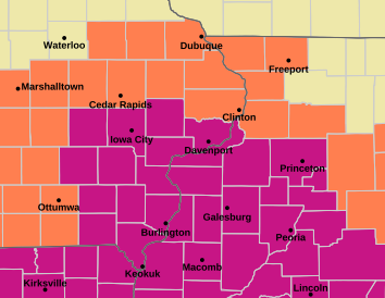



Davenport, Bettendorf, Moline, Rock Island and Muscatine remain under the warning until 7 p.m. Friday. Central Iowa is under a separate Heat Advisory.
By Hola America News
QUAD CITIES — Dangerous heat will continue across the Quad Cities through Friday. In some areas, the heat index could reach between 100 and 110 degrees.

An Extreme Heat Warning remains in effect until 7 p.m. Friday, Sept. 4. It covers Davenport, Bettendorf, Moline, Rock Island, Muscatine, Iowa City and several nearby communities.
In Davenport, temperatures could climb into the mid-90s Friday. However, high humidity could make it feel as hot as 107 degrees.
Meanwhile, central and south-central Iowa are under a separate Heat Advisory through 7 p.m. Friday. That advisory includes Des Moines, West Des Moines, Newton, Indianola, Pella and Ottumwa. Heat index values there could reach about 103 degrees.

The warning includes Scott, Rock Island and Muscatine counties
The Extreme Heat Warning covers much of eastern Iowa and western Illinois.

In Iowa, it includes Scott, Muscatine, Johnson, Cedar, Iowa, Keokuk, Washington, Louisa, Jefferson, Henry, Des Moines, Van Buren and Lee counties.
Across the Mississippi River, the warning includes Rock Island, Henry, Bureau, Putnam, Mercer, Henderson, Warren, Hancock and McDonough counties in Illinois.

As a result, Davenport, Bettendorf, Moline, Rock Island, Muscatine, Iowa City, Burlington, Fort Madison, Washington and Mount Pleasant are all within the warning area.
Related: Dangerous humid heat is rising in the Midwest for farmworkers
Davenport could feel as hot as 107 degrees Friday
Temperatures around Davenport and the central Quad Cities will stay in the mid-90s through Friday. In addition, high humidity will make the air feel much hotter.
For Davenport, the National Weather Service forecasts a Friday high near 95 degrees. The heat index could rise to 107 degrees.
Relief will also be limited overnight. Thursday night temperatures are expected to fall only into the mid-70s around the Quad Cities.
Therefore, homes without strong cooling may remain warm even after sunset.
Strong storms could develop north of Interstate 80
Heat is not the only weather threat in the region. Isolated strong to severe thunderstorms could also develop Thursday afternoon and evening.
Another round of storms could form by Friday morning. Areas north of Interstate 80 have the higher risk.
Damaging wind is the main concern. Hail is also possible in some storms.
Still, extreme heat remains the primary weather hazard through Friday. Scattered storms may continue at times into the weekend.
Des Moines remains under a Heat Advisory through Friday
Central Iowa is also dealing with dangerous heat. However, much of that area is under a Heat Advisory instead of an Extreme Heat Warning.
The advisory includes Polk, Dallas, Jasper, Warren, Madison and Marion counties, along with several other counties in central and southern Iowa.
Des Moines is also included. Across the advisory area, heat index values could reach about 103 degrees.
In Des Moines itself, Friday’s heat index could climb to around 105 degrees.
NWS advises reducing time outside during peak heat
Extreme heat and humidity can quickly increase the risk of heat-related illness. Therefore, the National Weather Service recommends drinking plenty of fluids and spending time in air-conditioned spaces.
In addition, strenuous outdoor activity is best limited during the hottest part of the day.
Children and pets should never stay inside unattended vehicles. Car interiors can reach dangerous temperatures within minutes.
People who work or spend long periods outdoors face a higher risk during this kind of heat. Current warnings and forecast changes are available from the National Weather Service Quad Cities.
The Extreme Heat Warning for the Quad Cities is currently scheduled to end at 7 p.m. Friday, Sept. 4. Meanwhile, the Heat Advisory for Des Moines and parts of central Iowa also remains in effect through 7 p.m. Friday.
Stay in the know with stories that matter — visit HolaAmericaNews.com for the latest news, culture and community updates!
Facebook Comments