
By Kyle Werner, Des Moines Register
The forecast for a storm expected to affect most of Iowa has intensified.

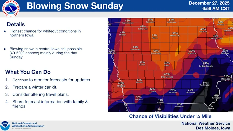
The National Weather Service in Des Moines says expected snowfall amounts on Sunday, Dec. 28, could reach up to an inch in central Iowa, 2 inches in Ames and Cedar Rapids and as much as 4 inches along the Minnesota border, where high winds may bring blizzard conditions, including whiteouts. A winter storm watch has been issued for that area.
At the same time, the weather service said there is less likelihood than earlier forecast for the snow to be preceded by freezing rain, though sleet is possible.
The snow is expected to start after 6 a.m., peak between noon and 8 p.m. and end late Sunday, the weather service said. It will be accompanied by winds up to 35 mph, with gust to 45 mph. The agency warned that throughout the state, blowing snow may make travel hazardous, noting that it’s wind, not heavy snow, that creates a blizzard.
Temperatures are expected to fall throughout Sunday, starting at a high of 44 degrees and dropping to a low of 10 in central Iowa. Windchill will make it feel like -8, the weather service said.

The greatest snowfall is expected in far northeastern Iowa, with Decorah forecast to get 2-4 inches while Sheldon, Estherville and Mason City can expect 1-4 inches.
It’s possible that more southerly areas, including Iowa City, could get a trace of snow or none, depending on how the storm develops.

More snow and wind bring lower temperatures
The weather service said sunshine should return Monday, but with a high of 17 and continued wind until the evening. The low is expected to be a blustery 8 degrees.

Tuesday could bring a bit of a warmup, with a high of 33 and a low of 20 in the evening as clouds move in.

Wednesday’s forecast calls for cloudy skies with a high near 31 and a low of 7, and New Year’s Day will be sunnier but colder, with a high of 17 and a low around 5.
Farther east, condition could be more extreme as the week begins, with a full-on blizzard possible in the Great Lakes region, the weather service said.
Polk County to activate extreme temperature plan
In response to Sunday’s forecast, Polk County Emergency Management said it will activate its extreme temperature plan at 4 p.m. Sunday. The county activates the plan when temperatures reach certain thresholds: 10 degrees with wind chill for three or more days, 5 degrees with wind chill for two or more days or 0 degrees or less with wind chill for at least one day.
The plan includes weather amnesty at Central Iowa Shelter and Services, temporarily removing limitations on shelter nights; the opening of warming centers across the metro; and free transportation to the centers via DART bus service.
Where are warming shelters in Des Moines and central Iowa?
Warming centers in Des Moines include:
- Des Moines Scott-Four Mile Community Recreation Center, 3711 Easton Blvd.
- South Side Library, 1111 Porter Ave.
- Central Library, 1000 Grand Ave.
- Forest Avenue Library,1326 Forest Ave.
- Northwest Community Center, 5110 Franklin Ave.
- Polk County Health Department, 1907 Carpenter Ave.
A full list of available warming centers can be found on the Polk County website, polkcountyiowa.gov. The county recommends calling ahead to check for availability. See which centers are along DART bus routes on the DART website, ridedart.com.
Stay in the know with stories that matter — visit HolaAmericaNews.com for the latest news, culture, and community updates!
Facebook Comments